A while ago I decided to take a new direction in my life and not get another job after I finished up my last entomology contract. That approach sounds like fun, right? But, there are a couple of problems: I like money. I like doing something meaningful with my time. I like being around other people working towards an outcome and sharing in achievements. With this in mind I thought I could perhaps start a very small business. I live at the beach and love riding my fat bike on the beach and on the sand tracks. I’m sure other people would love this too, so the idea of starting up a fat bike hire business arose in my mind.

I don’t have a massive amount of capital to invest, so I thought I’d probably start with two or three bikes. I reckon I can do this, I thought. I don’t know a great deal about how to do any of this, so like any other reasonable person I thought I’d start my market research to find out whatever I could. I put a post on the local community fakebook page. This is what I asked, “Do people think a fat bike (pushbike, not electric) hire would work here? They’re bikes for riding on the beach and on the sand tracks. The tyres are from 3.8″ to 5.5″ wide. You can still ride them like a normal bike on roads and gravel too. Thoughts?”
Holy shit balls! It went south pretty fast. The first six responses were level-headed responses with people giving honest and useful feedback about whether they thought it would work or not work, but it was all downhill after that. People started attacking each other’s characters, pasts and motivations. I didn’t get involved in any of the arguments because what’s the point? But I guess it was pretty entertaining if nothing else. It was also really amazing to see how total strangers could formulate opinions of me (and of each other) based on me asking about a bike hire business. Why do people even care about this stuff, I wondered outloud as I watched the comments roll in:
First it’s bikes then it’s scooters, then mini bikes dirt bikes [sic], quads and jeeps and full blown 4X4 The same contributor went on to write, Interpreting from your own words that you clearly don’t get enough of a high from just sitting and enjoying the beach you feel the need to add the “high” of riding a bike along it to make it a better experience for you and now you want to market that artificial high for others to also enjoy because you can make the experience “better” than what nature provides. This person seemed to think that somehow I was going to turn Woodgate into another Gold Coast. Man, I’d love to have that power (I probably would use it for something else other than making a second Gold Coast, maybe equality? Hmm?), but I just don’t, I really don’t have that power. I’m just one person who wants to live a meaningful life. Asking too much? Maybe in this town it is. I just don’t know.
See, the thing is, nature doesn’t belong to us, we belong to nature and we all like to experience our connection with the natural world in different ways. I don’t like to go fishing. Does that mean I’m a bad person or that I think people who fish are bad? No. It just means I don’t like to go fishing, so I don’t do it and then I get on with my life. Problem solved, if there even was a problem to begin with, which there wasn’t because I can’t see the point of catrastophising about unrealistic futures that will never eventuate, like theme parks in Woodgate. Although, I did wonder how the group might react if I put up a post asking their thoughts on a waterslide activity park. That was really tempting, but because I’m not an arsehole I didn’t do it.
There is an interesting peer reviewed article here about how tourism operators can create experiences that result in conservation outcomes. I have a Bachelor of Environmental Science majoring in Ecotourism and understand that if more people are given a way to interact with the natural world it improves outcomes for sustainability and conservation because the more people know about something, the more they can care about it.
I’m not a social researcher or anything, but it does seem to me that people who live here are in a constant state of fear. They all seem to hate anything new, any new business, any new building, any new people moving here. I think they don’t like this stuff because they’re worried that if stuff changes that means there will be less for them. It’s like the equality thing where people who are against equality freak out because they think it’s pie: more for other poeple means less for them, but the thing is, there is no pie. Having more equality and more non-destructive ways to experience nature will only ever mean we get to live better lives.
That is if we can get past this sort of shit:
Clearly nature is not enough for you. You have no foresight [sic] or business planning. Old pricks. Sad old people. Go to a nursing home. Get fixed wombat.
Adopting a more constructive way of seeing the world would help here. Getting out of the echo chambers would help because then everyone could embrace a larger life. Imagine a world where you aren’t held back by your beliefs or need to feel like you are the one who is right ALL the time. We live in reality, not inside fakebook and the internet. We only get one life and we should be living it, not worrying about stupid shit online.
I read a book recently called Stolen Focus by Johann Hari. He said in the book somewhere that people have used up over 200 000 human lifetimes by spending time on mindless internet bullshit. Arguing about stupid shit online on inconsequential fakebook community groups is a waste of your life. I just can’t understand why people do it. People really need to read Mark Manson’s book, The Subtle Art of Not Giving a Fuck.
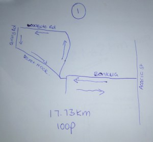
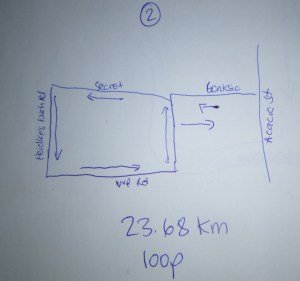
As for me, I’m still not sure about the bike hire business and my role as the Bike Hire Antichrist. I’m tossing up a few other ideas as well. I certainly won’t bother putting any more posts on the local community fakebook group, that’s for sure. So, I’ll keep doing my thing (the artificial high stuff) and it’ll look like some of this:


I’m not doing this job anymore, but I still like flies, which occur in the natural world and are an important part of all ecosystems. This particular species is native to Australia https://en.wikipedia.org/wiki/Inopus